Mountaineering villages

Look up
At a time when mountaineering has been declared aUNESCO World Heritage Site, seven of the Ecrins region’s most famous sites(La Grave, Villar-d’Arène, Le Monêtier-les-Bains, Vallouise-Pelvoux, La Chapelle-en-Valgaudemar, Saint-Christophe-en-Oisans and Valjouffrey) are launching a joint initiative. Their aim: to re-enchant their villages, cradles of the discipline, to promote authentic, respectful mountaineering, to pass on the tradition to new generations, and to raise public awareness of the fragile beauty of the natural environment.
on the beauty and fragility of nature


The big
story
With over 150 peaks above 3,000 m and the glaciers that crown them, the imposing Écrins massif is a mountaineering myth in France. The Barre des Écrins (4,102 m) was the country’s highest peak until 1860, when Savoie was annexed to France. History will record the name of British climber Edward Whymper, who made the first ascent of the summit in 1864, as well as those of the Rodier, Siemond, Engilberge and Estienne brotherhoods of local guides , and the famous Pierre Gaspard de la Bérarde, known as “Gaspard de la Meije”. In 1903, the Club Alpin Français built the first refuge in the cirque du glacier blanc, the Caron shelter. And 1973 marked the birth of the National Park. It was here, in the mountaineering villages of the Écrins, that the pioneers wrote mountain history.

Upstairs
from the top!
La Grave, Villar-d’Arène, Le Monêtier-les-Bains, Vallouise-Pelvoux, La Chapelle-en-Valgaudemar, Saint-Christophe-en-Oisans and Valjouffrey.
It all begins and ends here: mountaineering courses to the Grand Pic de la Meije, l’Olan or the Aiguilles de la Bérarde, the Grand Tour des Écrins itinerary via the GR54, climbing on theAilefroide cliffs, hikes to one of the massif’s thirty refuges, including the famousAigle refuge, family outings to Voile de la mariée at Gioberney or Pré de Madame Carle at Ailefroide, the spectacle of glaciers and high-altitude lakes. Seven mountaineering villages in the Écrins, as many base camps within the eponymous national park. Villages where the hearts of passionate men and women beat: hut wardens, mountain guides, rangers, park scientists, for whom sharing and solidarity reflect mountain identity and traditions. Places where the culture of mountaineering has been passed on for generations.

The
balance point
The Bergsteigerdörfer initiative was launched in Austria in 2008. The initiative then spread to Germany, Italy, Slovenia and Switzerland. Today, some thirty villages in Europe are involved. The mountaineering villages of the Écrins are freely inspired by this concept. Eager to assert their “high mountain” positioning and specificity, they have adapted it and hope to eventually draw other villages in the

One massif, seven villages to discover.
Like the base camps of the great expeditions and all the imagination that goes with them, mountaineering villages are historic departure points for the great mountaineering races to emblematic summits. They are places to prepare for an adventure, a walk or a hike to one of the massif’s special features: a summit, a waterfall or a spectacular viewpoint. ” Nothing is more beautiful than the simple things”, as the saying goes.
To discover them, follow the path of the Mountaineering Villages.

“The Himalayan of the AlpsLaChapelle-en-Valgaudemar
The village of La Chapelle-en-Valgaudemar lies at the bottom of a valley along the Séveraisse torrent. It’s a narrow, east-west valley surrounded by peaks over 3,000 meters high, and exceptional steep landscapes, “the French Himalayas” for Gaston Rébuffat. Here, you’ll still find houses with a distinctive architectural feature: the tounes (vaults housing the front door). Starting out from the village, you’ll find numerous hiking and mountaineering routes, a Nordic site, typical hamlets(Les Portes, Le Casset, le Rif du Sap, etc.), natural attractions (high altitude lakes, waterfalls, Oulles du Diable, cirque du Gioberney, etc.), and numerous peaks topping 3,000 m, including l’Olan (3,564 m), les Rouies (3,589 m), les Bans (3,669 m) and le Sirac (3,440 m).

Climbing at the foot of the glaciers
Vallouise-Pelvoux and Ailefroide
The mountaineering village of Vallouise-Pelvoux, with its hamlet of Ailefroide, is one of France’ s leading mountaineering destinations (2nd only to Chamonix). At the foot of Mont Pelvoux, Ailefroide, a timeless hamlet, has retained its authentic character with its typical stone houses. This listed natural site is only inhabited in summer. It’s the base camp for all mountaineering, climbing and hiking enthusiasts. From here, trails lead to the highest peaks in the

The masterly Casset
Le Monêtier-les-Bains, hamlet of Casset
Best known for its Grands Bains and the Serre Chevalier ski slopes, Monêtier-les-Bains is also home to a typical mountain hamlet called Le Casset. Situated on the banks of the Guisane, Le Casset is the starting point for the Grand and Petit Tabuc valleys , gateways to one of the massif’s greatest peaks: the Montagne des Agneaux, which rises to 3,664 m. But the lack of a refuge on this side of the mountain means that climbers prefer to access the normal route from the

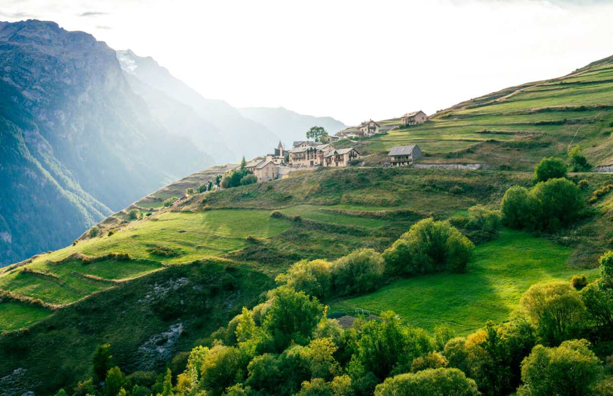
The terraced village
Villar-d’Arène
Villar-d’Arène and its two hamlets, Pied du Col (1,705 m) and Les Cours (1,779 m), have preserved their heritage of character, marked by agriculture and pastoralism. Traditional houses, chapels and fountains make for a pleasant discovery. The chapel of Saint-Antoine, near the hamlet of Cours, offers a lovely view over the valley, and bears witness to ancestral agriculture with its terraced cultivation. From the Pont d’Arsine, trails lead to various mountain refuges: Chamoissière, l’Alpe de Villar d’Arène, le Pavé, Adèle Planchard and l’Aigle. A little higher up, at the Col du Lautaret (2,058 m), you’ll find the Jardin Alpin, a veritable center for mountain science and research. This high-altitude botanical garden boasts over 2,000 species of mountain plants and flowers from all over the world.
Mountaineering at your fingertips
La Grave
There are few Alpine valleys where you can contemplate such a grandiose panorama from your door or window. Here, from the steep lanes that climb up to the Church of the Assumption, you feel very small in the face of the immensity of the surrounding landscape, in the shadow of one of the most famous peaks in the Alps:the Grand Pic de la Meije at 3,982 m. La Grave is listed as one of France’s most beautiful villages, thanks to its panoramic location at an altitude of 1,500 m and its authentic atmosphere. It is said that the village was once surrounded by a fortified wall, which has now completely disappeared. The village has retained a tightly woven urban fabric, as evidenced by the numerous “trabuc” lanes linking the houses. With the creation of the Glaciers de la Meije cable car in 1976, the La Grave La Meije ski area became a unique off-piste area in the Alps, with a single run on the glacier and up to 2,150 m of vertical drop on all terrain, from the high mountains to the river at the bottom of the valley.

The country of Gaspard De La Meije
Saint-Christophe-en-Oisans
A veritable stronghold of mountaineering, with nine refuges and two alpine centers, Saint-Christophe-en-Oisans is the benchmark for high-mountain activities in Oisans, along with the hamlet of La Bérarde. The natural wealth and wild character of this glacial valley make it ideal for hiking. Saint-Christophe-en-Oisans alone occupies one-fifth of the surface area of the Ecrins National Park. High mountains surround it on all sides: 128 peaks over 3,000 m, including La Meije (3,982 m), La Barre des Ecrins (4,102 m), Les Rouies (3,589 m) and Les Bans (3,669 m). In the heart of the village “La Ville”, a stone’s throw from the moving cemetery where famous mountain guides are buried, the “Mémoire d’alpinismes ” museum is open to all mountain lovers. At the bottom of the valley, the Vénéon, with its limpid, often turquoise-blue waters, and the torrents and waterfalls of the adjacent valleys.

Rural village, raw and natural
Valjouffrey
The commune of Valjouffrey, located on the western side of the Ecrins massif, is exposed to the climatic influences of the outer Alps. Extensive forest cover has developed, particularly on the left banks of the Bonne and Béranger rivers, between 900 and 1,800 m altitude. Deeply carved out by Quaternary glaciers, the upper Bonne valley has a very rugged relief, with a string of peaks over 3,000 m high. The 3,565 m peak at Pic de l’Olan and the surrounding peaks give this commune a very “high mountain” feel. The commune’s hamlets are scattered throughout the valley, as close as possible to farmland: La Chapelle-en-Valjouffrey, La Chalp, Les Faures, Le Désert, and in the secondary Béranger valley , Valsenestre.
Practical notebook
- Carte
- Topo guide écoles d’alpinisme
- Villages d’alpinisme des Écrins, le livre

